Director / cut: APACH, Thomas Voillaume.

Thursday, November 20, 2014
Wednesday, September 10, 2014
Second to none!
One objective - three teams
As is often the case with good ideas, several teams have them at the same time. For the circumnavigation of the Greenland icecap, this is no different. Already the Norvegian team pioneering the route from Narsaq in the south to Qaanaaq in the north on skis in 2005 gave it a thought to return all the way back home. Once a few more teams had successfully repeated this trip, the possibility to efficiently use catabatic wind systems for long distance kiting in Greenland was taken for granted. By extrapolation, it appeared only logic, that a circumnavigation of the entire icecap should be possible. And soon, the idea was hovering around in the small community of polar kiters.It took some time until somebody made a move, until finally this year not one, but three teams announced that they would attempt the first circumnavigation of the Greenland Icecap!
- Dixie Dansercoer and Eric Mc Nair - Landry with "Greenland Ice 2014"
- Ramon Larramendi, Hugo Svensson, Karin Moe Bojsen, Manuel Olivera and Eusebio Beamonte with "Trineo de Viento / Inuit Windlsed"
- and ourselves with "Wings over Greenland II".
Different choices - different achievements
Each of the three teams had their very own approach, different starting points, different equipment and their own solutions to the challenges of this gigantic endeavour. And each team was facing the unknown. In the end, all three expeditions were a success and each team has its own achievements:- Dixie and Eric were first and foremost: 'first'. First to set out and first to close their circle of 4045 km, enclosing about 34 percent of the Icecap.
- We came in second. With 5067 km Wings Over Greenland II became the longest unsupported ride ever. And including approximately 51 percent of the icecap surface makes it the most complete of the three circumnavigations.
- Trineo de Viento / Inuit Windsled certainly had the most innovative approach with their windsled allowing them to kite round the clock and to ferry a huge payload. And in the end they were the fastest, finished in the shortest time had the longest day of the three expeditions witha leg of 427 km! Short of the 'South Dome' they still rounded about 30 percent of the icecap.
 |
Circumnavigated surface in percent of the entire Greenland ice sheet.
a) Wings over Greenland II: 51% b) Greenlad Ice 2014: 34% c) Tierras Polares 2014: 30%.
|
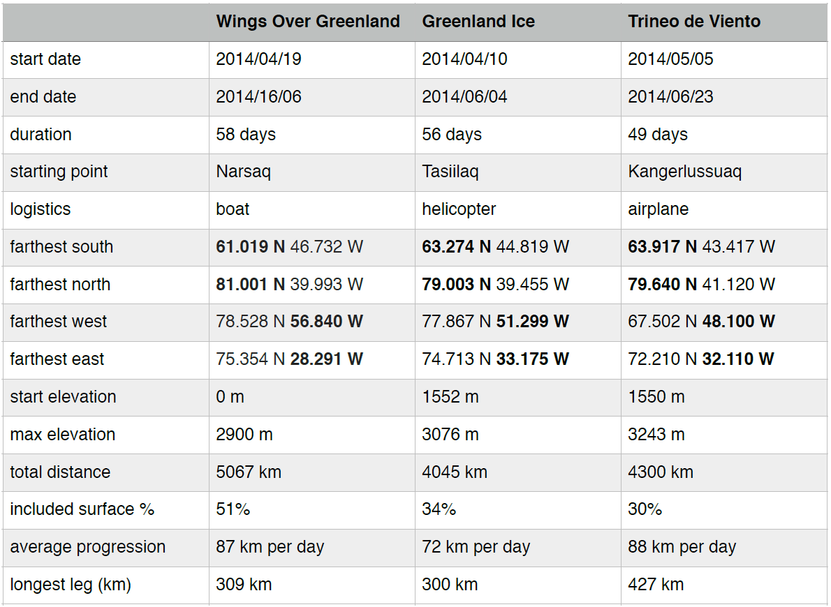 |
| Comparative table. Three teams, one goal. Three different approaches. Each has their own achievements. |
Coast to coast!
The three expeditions had chosen different starting points, and logistics to reach the icecap.- Greenland Ice opted for a Helicopter drop-off on Greenspeed Ridge, close to Ammassalik, frequently used as a starting point for classic east-west crossings.
- Trineo de Viento flew their team of five and huge amount of gear by plane from Kangerlussuaq onto the icecap.
- We absolutely wanted to rely on minimal logistics only, and it meant a lot to us to start and finish at sea level. We therefore chose transport by small boats from Narsaq to our starting point in Qaleraligd Fjord.
 |
| We absolutely wanted our trip to start and end at sea level and to use only minimal logistics. Laasinnguaq dropped us off on the sea ice that beset the end of Qaleraligd Fjord with the 'Tattak'. Carl picked us up with a small open fishing boat. |
The different choices in starting points, and logistics are also reflected in the elevation profiles of the three expeditions.
 |
| Elevation profiles for the three expeditions. |
Wings over Greenland II does not cut on corners!
The meaning of an icecap circumnavigation would be a vast subject on its own. Contrary to sailing around an island, there are no simple criteria, and everyone just did the best with the conditions at hand. On our side, we tried to round as much of the icecap as possible. And we simply did not want to cut on corners. Starting far south in Qaleraligd Fjord, we covered nearly 20 degrees of latitude up to our turning point at the 'confluence' of latitude 81 N with meridian 40 W. And in our futile diversion to home in on the automatic weather station Humboldt-Glacier on our way up, and to get as close as possible to the mountains during our way down, we went further east and west than the other teams. Admittedly, west and east are 'cheap' at high latitude. And in the process we covered the largest percentage of the icecap surface, making Wings over Greenland II the most complete circumnavigation today. Greenland Ice did just round 'South Dome', the southern summit of the icecap, whereas Inuit Windsled finally had to cut north of it to our understanding.Wings over Greenland goes the extra mile!
When Dixie and Eric celebrated the 'first' circumnavigation of the Greenland Icecap with beer and shower, we had already covered more than 4000 km and still a long way to go. Actually long enough to beat the previous record for the longest trip on skis in full autonomy by Dixie Dansercoer and Sam Deltour. At the time of writing Wings over Greenland is the longest ride ever.Certainly, we came in second. But all things considered we think: second to none!
Its safe to assume, that the others have similar feelings regarding their own expedition. Each team has their very own achievements. Congratualtions! We had a fun time 'competing' out there!
Disclaimer
The fine print: The comparison shown here is based on data that was made publicly available on the three teams websites. The different claims and achievements are sufficiently clear that there should be no ambiguity. Yet for the matter of completeness, and to illustrate the difficulty of dealing with this type of data we would like to point out the following issues:
GPS points:
All three expeditions gave regular updates and made their positions public. Yet unfortunately there is sometimes confusion with the respective GPS formats used (for ex. degrees minutes seconds vs decimal degrees) and there are some more or less obvious typos (for ex. different maps of the spanish team show slightly different positions and values differing by exactly one digit).
Distances:
Measuring distances at this scale is far from obvious. Great circle distances? Great circle distances including the ellipticity of the idealized surface of the earth? Including elevation?
From camp to camp (that what we have used)? From stop to stop? How many updates, when kiting round the clock in shift work like Inuit Windsled? The trip odometer including tacking? This is where the included surface becomes an interesting measure - tacking would somehow average out.
Area / surface:From camp to camp (that what we have used)? From stop to stop? How many updates, when kiting round the clock in shift work like Inuit Windsled? The trip odometer including tacking? This is where the included surface becomes an interesting measure - tacking would somehow average out.
Calculating the surface of a weirdly shaped polygon (our respective routes) wrapped on an supposedly elliptical surface (earth) with corners at different elevations (waypoints) is even more tricky. We tried to get it approximately right, evaluating the surface with the Geographic Information System software package QGIS Chugiak 2.4.0 using the WGS 84 ellipsoid.
Wednesday, September 3, 2014
The Longest Ride
During our circumnavigation of the Greenland icecap we covered a total of 5067 km!
 |
5067 km. The longest ride ever. Wings Over Greenland II, 2014, Michael
Charavin and Cornelius Strohm. Start and end at sea level in Qaleraligd
Fjord, close to Narsaq. Click to enlarge.
|
Just enough to beat the previous record of 5013 km established by Dixie Dansercoer and Sam Deltour in their attempt to circumnavigate East Antarctica with the "Antarctic Ice Expedition" in 2011-12.
 |
| 5013 km. Antarctic Ice 2011-12, Dixie Dansercoer and Sam Deltour. Points were taken from the book "Beyond the challenge". Not all intermediate positions were reported. Start and end: drop-off and pick-up on the icecap by airplane. Click to enlarge. |
Which had exceeded the former longest ski trip of 4804 km by Rune Gjeldnes on his "Join! expedition" in 2005-06.
 |
| 4804 km. Join! expedition 2005-06, Rune Gjeldnes. Points were taken from the book "Beyond the poles". Start: Novolazarevskaya Station in Queen Maud Land, end at sea level in Terra Nova Bay in Victoria Land. Click to enlarge. |
We are excited to see what will come next! There is still a little room for more in Greenland, and a look at the map of Antarctica allows one to dream of distances beyond 7000 km! If someone has the necessary ideas, courage, and legs strong enough to set out and complete Dixies original plan...
Distances, as given by the expeditions. In our case: as calculated by the Garmin Foretrex 301, including start, landfall, camps and arrival.
Books:
"Beyond The Poles" by Rune GjeldnesISBN 978-82-995661-4-8
The book can be ordered from Runes website: Rune Gjeldnes, Adventurer and Lecturer
"Beyond The Challenge" by Dixie Dansercoer and Sam Deltour
ISBN 978-94-6161-052-2
The book is available through amazon.com
Wednesday, August 13, 2014
Photo Gallery and Video Trailer
We now have a photo gallery online!
Wings Over Greenland II Gallery
Mika is still in Iceland for work, and with him basically all of the video footage. Until he is back, and the time to edit a full length video, a short trailer made from a few shaky sequences with one of the still- and one of the POV-cameras will have to do...
Friday, August 8, 2014
Temperatures
The inland ice of Greenland is definitely a cold place. And one of the first questions many people ask when talking about our expeditions is on how cold it actually was. Yet the answer is far from obvious. And even though we almost always carry a thermometer, we rarely ever have a look at it. And when we take a measurement, its often because the weather either feels remarkably cool or warm. But what about the average? The lowest temperature at night? The maximum temperature during daytime?
Wouldn't it be nice to have a continuous recording?
At first sight, there is a huge choice of temperature loggers available on the market. But a closer look immediately rules out most offers by the demands imposed by polar kiting expeditions:
To make this a bit more visible, the next graph shows the evolution of the daily average temperatures, along with the minimum and maximum values. (The minima and maxima were determined using a moving average over 1 hour, in order to smooth out spikes.)
We have passed two automatic weather stations on the icecap (Nasa-U: news "Sport meets Science" and Humboldt-Gl: news "Humboldt - turn right".). It will be interesting to compare the temperatures for these days, as soon as this years data from the weather stations becomes public (supposedly soon).
The following graph shows the temperature inside the tent together with the outside temperature for one week starting on saturday 17/05. Its impressive how much the tent (Helsport Svalbard 5 Camp) with its yellow and red tissue heats up in direct sunlight.
Temperature loggers for cold chain surveillance are a simple, way to document the conditions during a polar expedition. They are intrinsically robust, have a long battery life and are made for continuous use at low temperatures. It turns out, that getting correct temperature readings is anything but an easy task! It is worth to be carful with the packing and and to think about the placement of the loggers. I would do it differently next time. Pulks, bags and tents heat up far above outside temperatures. Speaking of cold chain surveillance: it is far from safe to assume that the food is always below freezing temperatures during a polar expedition.
The software required to read the logger is only available for windows, and the battery is not user replaceable.
If you are interested in using this type of logger during an expedition, drop me a line, I would be glad to help and to share experience - properly done, learning from our mistakes, carrying loggers is certainly worth the effort!
Thanks to Florian for helping me out with a windows computer to read the data loggers - I do not own such a thing anymore.
Wouldn't it be nice to have a continuous recording?
Cold chain surveillance
At first sight, there is a huge choice of temperature loggers available on the market. But a closer look immediately rules out most offers by the demands imposed by polar kiting expeditions:
- temperatures down to -40 degrees Celsius
- autonomy (memory and battery) of more than 2 months
- shock-proof
- small, lightweight package
- small, lightweight package
- easy connectivity, preferably via USB port
- a data format allowing simple extraction of the data for further treatment and presentation
- resolution better than 1 degree Celsius
- affordable price
To my surprise, there is one industrial application meeting exactly all the above specifications: temperature loggers for cold chain surveillance of frozen food and medicals. After some research on the web, I settled on the 3M TL30 (manufacturers website) and bought two units for a test during Wings Over Greenland II.
 |
We had two 3M TL30 temperature loggers. Originally they are intended for
cold chain surveillance. They are small, lightweight (30 g)have an autonomy
of up to one year and are not afraid of cold temperatures. We protected them in plastic bags against moisture and white (spectacle) pouches from absorption of sunlight. |
In order to avoid malfunction due to condensation or accidental immersion (sea ice, surface melt puddles) the units were sealed in tiny plastic zip-lock bags. Professional outside thermometers have sophisticated ventilated white housings to avoid absorption of direct sunlight. As a first approximation, I packed our loggers in small, white spectacle pouches, that I found at the french sport store "Decathlon".
How and where to measure?
As with every new device, it takes some time to figure out how to use it, and in this case also to define some routine. And so, the units sadly spent the first part of the trip waiting inside an electronics bag, that rarely ever left the sled. In the meanwhile we observed, that the pulks and our new yellow/red tent heated up considerably during daytime and got interested in temperatures again. Only then did I decide the units should be outside the pulks during progression, and one outside and one inside the tent at the camps respectively. From camp 16 on, unit 1 was placed outside the tent, and from camp 20 on, unit 2 inside the inner tent pocket close to the entrance. During progression both were attached to a small backpack that I always wore to carry a few fragile things.
 |
| At the camps, logger number 1 left outside, close to the tent entrance. It was covered with a few centimetres of snow to avoid direct illumination. |
 |
| At the camps, logger number 2 was stowed away inside one of the tent pockets in order to get an estimation of the inside temperature. It would have been better to suspend it somewhere in the middle, to avoid direct heating through the tent wall when the sun was on this side of the tent. |
 |
| During progression both loggers were attached to my backpack. Next time I would avoid attaching them to a black surface. |
These were practical choices and all three locations have their shortcomings:
The backpack is black and tends to heat up, at least when its not exposed to the wind. This becomes particularly apparent in little marked spikes in the outside temperature, just before sensor 1 was put onto the snow during camp. But also during the days there are spikes that are too sharp to be realistic. Its likely that at least the maximum temperatures are exaggerated.
Because of the wind, logger 1 was on the snow, attached to one of the tent pegs and covered with a few centimetres of snow at the camps. The snow surface temperature does not necessarily follow the air temperature.
The inside thermometer was always in the inner pocket close to the entrance. This may significantly exaggerate the reading depending on which side of the tent is exposed to the sun, and it would certainly have been more wise to suspend it somewhere in the middle of the tent.
But once I realised all of these issues, we had already completed a substantial part of the trip, and I thought it better not to change protocol once more mid-way.
I thought its worth sharing these experiences anyway.
How cold?
The following image shows the temperature trace of the "outside" logger 1 for the entire expedition. The black vertical line delimits the first part, where the logger was still inside the pulk, from the time, when it was systematically placed outside next the tent entrance or attached to my backpack. The large relative shift in the data makes the problem directly apparent.
The first striking observation are the large oscillations due to the diurnal variations of the temperature. The temperatures are strongly correlated with the height of the sun above the horizon. A closer look shows, that the average temperature is globally decreasing during the first half of the trip before rising again in the second half. This correlates well with the latitude, as the start and end of the trip was the southernmost point, and we reached the turning point at latitude 81 N on 19/05. At the same time, the diurnal variations appear to decrease while heading north and to slightly increase again on the way back south. The effect is however barely significant, as the days were still getting longer and cloud cover and the spikes in the data play an important role.
 |
| Temperature readings from logger number 1 (outside). Click to enlarge. |
To make this a bit more visible, the next graph shows the evolution of the daily average temperatures, along with the minimum and maximum values. (The minima and maxima were determined using a moving average over 1 hour, in order to smooth out spikes.)
 |
| Average temperatures (black), along with the minima and maxima. Click to enlarge. |
We have passed two automatic weather stations on the icecap (Nasa-U: news "Sport meets Science" and Humboldt-Gl: news "Humboldt - turn right".). It will be interesting to compare the temperatures for these days, as soon as this years data from the weather stations becomes public (supposedly soon).
Cosy interior
The following graph shows the temperature inside the tent together with the outside temperature for one week starting on saturday 17/05. Its impressive how much the tent (Helsport Svalbard 5 Camp) with its yellow and red tissue heats up in direct sunlight.
 |
Temperature readings from both loggers for the week from May 17.
Click to enlarge.
|
The image below of our 'analog' freezer thermometer and Mika, taken at the very beginning of the trip shows, that sometimes it can get really hot inside (news "Sauna")!
 |
The end of a polar myth: in direct sunlight, the temperatures inside the tent
can rise far above zero.
|
Lessons learned
Temperature loggers for cold chain surveillance are a simple, way to document the conditions during a polar expedition. They are intrinsically robust, have a long battery life and are made for continuous use at low temperatures. It turns out, that getting correct temperature readings is anything but an easy task! It is worth to be carful with the packing and and to think about the placement of the loggers. I would do it differently next time. Pulks, bags and tents heat up far above outside temperatures. Speaking of cold chain surveillance: it is far from safe to assume that the food is always below freezing temperatures during a polar expedition.
The software required to read the logger is only available for windows, and the battery is not user replaceable.
If you are interested in using this type of logger during an expedition, drop me a line, I would be glad to help and to share experience - properly done, learning from our mistakes, carrying loggers is certainly worth the effort!
Thanks to Florian for helping me out with a windows computer to read the data loggers - I do not own such a thing anymore.
Sunday, June 22, 2014
Time to say thank you!
We would like to thank all of you, family, close friends, and people unknown to us, who have shown interest in our adventure, followed our blog, and left kind encouraging messages to the expedition. During the two months out on the ice, we enjoyed reading your messages, forwarded by Romain and Laurent, as much as trying to share a little of our daily routine.
Admittedly, being watched and followed by others catalyzed new energy, when we had to surpass ourselves. Completing the same trip entirely incognito and without news from the outside world would have been a totally different challenge, - much closer to what the great explorers have achieved about a century ago ...
If we simply managed to convey our dream and distill some taste of adventure through our daily updates, we may have been able to give a little something back to you. And we may have reached one of our goals, share the experience for what it actually really was: the desire to surpass ourselves, the selfish pleasure to achieve something unique. Thanks to all of you!
We were only the two of us out on the ice. But in the shadow (no relation with the dark side of the force...) a small team of close friends had formed spontaneously around the project to run the office, forward your messages to us, and to provide all kind of necessary and unnecessary information:
- Maestro Laurent Jégu, logisic coordinator and chief webmaster. Laurent is a guide heading a small travel agency in Iceland (www.aventuresenislande.fr). If you would like to visit Iceland, his agency is certainly a good place to start! He also accepted the huge job of translating the french (Mika) and english posts (Cornelius) posts on our two blogs. Bravo and thanks a lot!
- Romain Moissard, secretary of the Association Wings over Greenland, chief postmaster, second webmaster, and coordinator of the communication on Facebook for Mika. A solid pillar to rely on in all circumstances!
- Rémi Charavin, Facebook coordinator for Mika. How many 'likes' thanks to you? A pleasure that you joined the team! And first virtual footprints in Greenland! Maybe a stepping stone to leave real traces on greenlandic soil or snow one day?
- Sylvie Boileau, Mikas girlfriend, and agent 008. In charge to inform us on the progression of the 'competing' team of Dixie and Eric. We simply called them 'the Belgians' - who knows why? Maybe because Canada is a small country ;-)....? Sylvie even got up during the night to check the position of her favorite team!
- Thomas Roth, a really trustworthy friend of Cornelius. The 'map guy' reporting our daily position on various maps, and agent 009 in charge to get intelligence on the position of the spanish team around Ramon, the inventor of the polar ice vessel, an ingenious kite powered sled raft. They would be surprised to find out about all the fantastic facilities and luxury we imagined this vessel would feature. Maybe it will make an appearance in the 7th episode of Star Wars?
- Not to forget Marc De Keyser, our very sympathic meteorologic router. We had contracted him for this expedition through: www.weather4expeditions.com. He really cared! Excellent double agent (joke), as he also routed 'the belgians' (true). He daily provided detailed yet clear weather and aerologic informations, gave precious routing advice and had always an encouraging word or two for us! You did much more than only the contract and the professional duty. Without you, this huge trip really would have become looong. Thanks also to his colleague Fritz who took over from time to time! Thanks for everything!
Team Wings over Greenland, - our achievement is also yours. We really appreciated you being part of this adventure and gratefully acknowledge your participation!
This project was nearly entirely self-funded. As we were at the limit of what we were able to finance ourselves, we created the Association 'Wings over Greenland' to raise some additional funds.
Laurence & Luc, Hervé, Pascal "Golgoth", Jérôme, Francis, Corinne, Bernard & Jacqueline, Cécile & Pedro, Nolwenn & Pauline, Amélie, Mathiouse: sincere thanks for your support and your contribution! Your names are forever attached to this circumnavigation of the Inlandsis!
Many thanks to our three official partners for believing in this project and to have followed the adventure:
- Roger (SNOWSLED Polar ltd, www.snowsled.com), its for the second time, that we partner up for a big kite-ski trip. And it was once more an incredible journey without any problem for the 'ice blue pulks'. You probably don't even imagine, what we had them go through? We feel safe to say, that if they they survived what we made them suffer, they likely can take everything. Excellent job once more with this 'new' bigger 'expedition' version. Thanks for the reliability of your equipment, the excellent preparation of the rafting kit and the double hull system, and your implication in our project.
- Ramon and Ernst from Flysurfer Kiteboarding. Thanks for trusting us. We are fully aware of our very particular and specific use of the Speed 3 19 m2 and Speed 4 10 m2 kites. We know that most of your clients are different from us and look for something else in these kites. But we believe that every kiter is somehow fueled by the spirit of adventure and dreaming of performing his preferred sport in wild and remote locations. Being with us in this endeavour, Flysurfer now owns the 'designers- and manufacturers-record' for the longest kite - ski trip ever realized!
- Oliv et Joh from the french magazine 'Carnets d'Aventures', thanks for all your messages of encouragement. Thanks for following us closely, and for relaying the information on the 'expemag' website (www.expemag.com) and its Facebook page. See you soon back home in the French Alps!
Saturday, June 21, 2014
Narsaq
We are still in Narsaq, a nice little village in southern Greenland featuring a natural harbour. The place is surrounded by fjords, islands, penninsulae and mountains. When we left at the end of winter, the landscape was wrapped in snow. What a surprise to find everything in vibrant green, when we came back here after two months on the ice.
 |
| When we left at the end of winter, the landscape was wrapped in snow. |
 |
| What a surprise to find everything in vibrant green, when we came back here after two months on the ice |
The people here do all they can to make our stay really pleasant. We had informed Jacky Simoud (Blue Ice Explorer: info@blueice.gl) about our expected date of arrival. All his boats were out this day, but he made sure there would be somebody who could pick us up. No later than half an hour after we had hauled the last bit of gear down the steep moraine in Qaleraligd Fjord, Karl picked us up with a small open boat. When we arrived at the harbour, Helgi Jonasson, the owner of the Narsaq Farmhouse hostel (helgioutfitter@greennet.gl) was already waiting with a trailor to drive us up to the Narsaq Farmhouse, where we could stay a few days to sort our stuff. He brought his friend Edward, who had been on the Sirius Patrol, to help us unloading and to share some experience.
The next morning, just after the first shower and the first night in a real bed, Paul Cohen, who had already helped us with our preparation in 2008, and once more this time, came to our place to welcome us to Narsaq.
One day later, Eloisa, who is working for Tierras Polares (the company of Ramon Larramendi who is still sailing the inlandsis) gave us a ride to 'town' and we had a little chat. Later, she and her friend Sergio surprised us at coffe time with a delicious home-made apple crumble they had prepared for us! The same evening we enjoyed an excellent dinner with local fish specialties and our first salad in more than two months at Monikas and Pauls place.
 |
| Sergio, Eloisa, the delicious homemade apple crumble, and Mika. |
We thought it would be practical to have a new crate of different dimension, to send all our equipment in one piece. In less than half a day, a local workshop had accomplished the job...
Thanks to all the people here in Narsaq!
The only thing we do not have yet, is a fast internet connection - we are still using our satellite modems or our cell phones. And, there are moskitos now.
Subscribe to:
Posts (Atom)