
One objective - three teams
As is often the case with good ideas, several teams have them at the same time. For the circumnavigation of the Greenland icecap, this is no different. Already the Norvegian team pioneering the route from Narsaq in the south to Qaanaaq in the north on skis in 2005 gave it a thought to return all the way back home. Once a few more teams had successfully repeated this trip, the possibility to efficiently use catabatic wind systems for long distance kiting in Greenland was taken for granted. By extrapolation, it appeared only logic, that a circumnavigation of the entire icecap should be possible. And soon, the idea was hovering around in the small community of polar kiters.It took some time until somebody made a move, until finally this year not one, but three teams announced that they would attempt the first circumnavigation of the Greenland Icecap!
- Dixie Dansercoer and Eric Mc Nair - Landry with "Greenland Ice 2014"
- Ramon Larramendi, Hugo Svensson, Karin Moe Bojsen, Manuel Olivera and Eusebio Beamonte with "Trineo de Viento / Inuit Windlsed"
- and ourselves with "Wings over Greenland II".
Different choices - different achievements
Each of the three teams had their very own approach, different starting points, different equipment and their own solutions to the challenges of this gigantic endeavour. And each team was facing the unknown. In the end, all three expeditions were a success and each team has its own achievements:- Dixie and Eric were first and foremost: 'first'. First to set out and first to close their circle of 4045 km, enclosing about 34 percent of the Icecap.
- We came in second. With 5067 km Wings Over Greenland II became the longest unsupported ride ever. And including approximately 51 percent of the icecap surface makes it the most complete of the three circumnavigations.
- Trineo de Viento / Inuit Windsled certainly had the most innovative approach with their windsled allowing them to kite round the clock and to ferry a huge payload. And in the end they were the fastest, finished in the shortest time had the longest day of the three expeditions witha leg of 427 km! Short of the 'South Dome' they still rounded about 30 percent of the icecap.
 |
Circumnavigated surface in percent of the entire Greenland ice sheet.
a) Wings over Greenland II: 51% b) Greenlad Ice 2014: 34% c) Tierras Polares 2014: 30%.
|
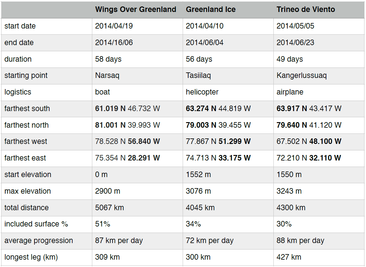 |
| Comparative table. Three teams, one goal. Three different approaches. Each has their own achievements. |
Coast to coast!
The three expeditions had chosen different starting points, and logistics to reach the icecap.- Greenland Ice opted for a Helicopter drop-off on Greenspeed Ridge, close to Ammassalik, frequently used as a starting point for classic east-west crossings.
- Trineo de Viento flew their team of five and huge amount of gear by plane from Kangerlussuaq onto the icecap.
- We absolutely wanted to rely on minimal logistics only, and it meant a lot to us to start and finish at sea level. We therefore chose transport by small boats from Narsaq to our starting point in Qaleraligd Fjord.
 |
| We absolutely wanted our trip to start and end at sea level and to use only minimal logistics. Laasinnguaq dropped us off on the sea ice that beset the end of Qaleraligd Fjord with the 'Tattak'. Carl picked us up with a small open fishing boat. |
The different choices in starting points, and logistics are also reflected in the elevation profiles of the three expeditions.
 |
| Elevation profiles for the three expeditions. |
Wings over Greenland II does not cut on corners!
The meaning of an icecap circumnavigation would be a vast subject on its own. Contrary to sailing around an island, there are no simple criteria, and everyone just did the best with the conditions at hand. On our side, we tried to round as much of the icecap as possible. And we simply did not want to cut on corners. Starting far south in Qaleraligd Fjord, we covered nearly 20 degrees of latitude up to our turning point at the 'confluence' of latitude 81 N with meridian 40 W. And in our futile diversion to home in on the automatic weather station Humboldt-Glacier on our way up, and to get as close as possible to the mountains during our way down, we went further east and west than the other teams. Admittedly, west and east are 'cheap' at high latitude. And in the process we covered the largest percentage of the icecap surface, making Wings over Greenland II the most complete circumnavigation today. Greenland Ice did just round 'South Dome', the southern summit of the icecap, whereas Inuit Windsled finally had to cut north of it to our understanding.Wings over Greenland goes the extra mile!
When Dixie and Eric celebrated the 'first' circumnavigation of the Greenland Icecap with beer and shower, we had already covered more than 4000 km and still a long way to go. Actually long enough to beat the previous record for the longest trip on skis in full autonomy by Dixie Dansercoer and Sam Deltour. At the time of writing Wings over Greenland is the longest ride ever.Certainly, we came in second. But all things considered we think: second to none!
Its safe to assume, that the others have similar feelings regarding their own expedition. Each team has their very own achievements. Congratualtions! We had a fun time 'competing' out there!
Disclaimer
The fine print: The comparison shown here is based on data that was made publicly available on the three teams websites. The different claims and achievements are sufficiently clear that there should be no ambiguity. Yet for the matter of completeness, and to illustrate the difficulty of dealing with this type of data we would like to point out the following issues:
GPS points:
All three expeditions gave regular updates and made their positions public. Yet unfortunately there is sometimes confusion with the respective GPS formats used (for ex. degrees minutes seconds vs decimal degrees) and there are some more or less obvious typos (for ex. different maps of the spanish team show slightly different positions and values differing by exactly one digit).
Distances:
Measuring distances at this scale is far from obvious. Great circle distances? Great circle distances including the ellipticity of the idealized surface of the earth? Including elevation?
From camp to camp (that what we have used)? From stop to stop? How many updates, when kiting round the clock in shift work like Inuit Windsled? The trip odometer including tacking? This is where the included surface becomes an interesting measure - tacking would somehow average out.
Area / surface:From camp to camp (that what we have used)? From stop to stop? How many updates, when kiting round the clock in shift work like Inuit Windsled? The trip odometer including tacking? This is where the included surface becomes an interesting measure - tacking would somehow average out.
Calculating the surface of a weirdly shaped polygon (our respective routes) wrapped on an supposedly elliptical surface (earth) with corners at different elevations (waypoints) is even more tricky. We tried to get it approximately right, evaluating the surface with the Geographic Information System software package QGIS Chugiak 2.4.0 using the WGS 84 ellipsoid.
No comments:
Post a Comment
Note: Only a member of this blog may post a comment.